Mount Whitney
Aug. 11, 2017
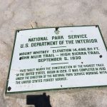
The Plan: Reach the summit of Mt. Whitney, the highest point in the contiguous 48 states at 14,505 feet.
A few years ago, Shannon and I took the kids on a trip to Southern California via Highway 395 south out of Reno. This is one of the great drives in America, running north-south along the eastern slope of the Sierra Nevada.
From Reno headed south, you run through the awesome Walker River canyon, can pop over to the Bodie Ghost Town (we went here back in June and I hope to have a quick post yet on this) and drive by the vast expanse of Mono Lake. Further south, you can jump off the highway to Mammoth Mountain, various hot springs, Crowley Lake, Convict Lake, ancient bristlecone pine forests, Alabama Hills (I bet you’ve seen these in a movie or two), Death Valley, etc. It’s a cool drive and there are ton of things to check out.
On this particular trip, we were driving through the Lone Pine area and I started thinking about Mt. Whitney. It’s the tallest point in the contiguous 48 United States. It would make for an incredible experience and accomplishment. At the time, I knew I wasn’t ready for it, but the idea stored away in the back of my head.
The thought came back last year, on the drive home from a hike on the Tahoe Rim Trail. I started reading up on it and set a reminder to enter the lottery in February. You’re allowed 15 date ranges on the lottery application, and can mix in overnight and day-hike requests. It’s six bucks to apply. Everything I’ve read notes that your chances are better with weekdays.
In late March, I got the confirmation of one of my dates for up to six people in my group. I remember the email arrived the morning that we left for an awesome spring break trip to Sayulita, Mexico, and I spent some time on the flight staring out of the window trying to catch a glimpse of Sequoia National Park as we flew south.
The epic winter we had in 2016-17, while making for an unreal ski seasons for us, did not help me with any of my plans to get ready for Whitney, however. Many mountain trails were socked in with snow through June and into July. While on a road trip to Oregon around the Fourth of July, I started working on alternative plans to get ready for Whitney. This included some higher altitude jaunts like Boundary Peak and Wheeler Peak. My friend Ryan, who summited Whitney a few years back, and who joined me for those two training hikes, gave me some assurance after Wheeler that I was ready for Whitney.
After securing the permits in April, in which you have to pay for all the permits in your reservation, we probably had no fewer than a dozen friends or family members tell us they were joining us for the hike. Then, a week before the hike, it was just down to Shannon and me, despite levels of commitment ranging from “Dude, count me in” to “That sounds awesome. I’m going to start training now” to “I’m trying to get a puppy today but if I don’t, I’m totally in next week.”
Thankfully, our great friend Krista didn’t get the puppy just yet.
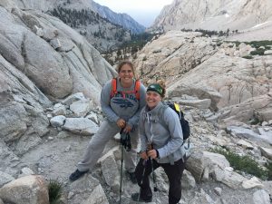
Krista is an incredibly happy person and basically is always up for any adventure, two pretty awesome qualities in a human being.
Shannon and Krista have worked together for a number of years. I picked them up about 2:30 p.m. on Thursday and we were off. Highway 395 pro tip: Top off your gas tank in Minden/Gardnerville. It’s probably the cheapest gas in Northern Nevada and prices will nearly double in towns like Bridgeport, Lee Vining, etc.
I had picked up this book the day before, initially as a bit of joke but once I thumbed through it, I realized it had some useful information. Shannon read through it during the drive and while reading a section about the potential of below-freezing temperatures during the summer, she realized she had forgotten to pack her jacket. We stopped in Bishop, Calif., for food and for Shannon and Krista to each get another layer of clothing.
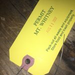
Back on the road, we made it to Lone Pine a little after 7 p.m. and picked up our permits from the night lockbox just south of town. We then backtracked a bit and set out on Whitney Portal road up to the campgrounds. From the moment I paid for our permits in April, the Whitney Portal Campground had been booked solid for our dates. We had reservations for Lone Pine Campground, which is considerably lower and not as much help in trying to acclimate to the altitude. We decided to go all the way up to the Portal to have a sense of where we would be starting from in the middle of the night and to check to see if anything in that campground might have opened. Thanks to an awesome park host named Bill, we were able to camp that night at the Portal.
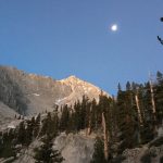
Because of the warnings about afternoon thunderstorms and the very real lightning threat around Whitney, I had wanted to be on the trail no later than 1 a.m. or so. But the forecasts were completely clear for a few days so we decided to get a little more sleep – about 3.5 hours total, I think – and woke at 2 a.m. We packed up camp and at 3:30 a.m., we were off from the trailhead, aided by headlamps and terrific moonlight.
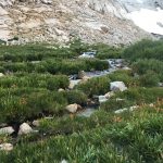
I had read a lot about the trail in preparation for the hike and I felt I had pretty good awareness of many of the challenges we would encounter during the day. The portal message board is an essential tool for very recent info on the trail conditions. There was great info there about all of the water on the trail and while we decided against packing water shoes, it was nice to be prepared to test the waterproofness of our boots or to take off boots and socks on the handful of areas where creeks were raging.
Furthermore, we all had plenty of water and food. We had requisite first aid. We had power for phones so we had dependable GPS. We had wag bags. We had layers of clothing and extra socks. We even had prescription Diamox to help with altitude illness, or Acute Mountain Sickness (AMS).
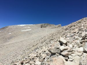
But until you actually do the hike, you don’t fully know what you are in for, and there are some unknowns that it is tough to account for. I had a timeframe in my head that I was hoping to hit in terms of reaching the summit and getting back to camp. By the time we hit Trailside Meadows, about five miles in and not even halfway up, I discarded that schedule. We had a clear forecast and this was a grueling endeavor – sticking to a schedule wasn’t the best play.

At that point, we had already lost nearly an hour due to the creek crossings, which required removal of boots and socks, crossing the creeks in bare feet trying not to lose footing on the slippery rocks, and then drying off and getting packed up again, in the dark. As we went on, something on my daypack wasn’t fitting me right and both hands were freezing cold and completely numb a few miles in, even after I put gloves on. During a stop, I completely unpacked the pack, adjusted all the straps and re-packed everything and within 15 minutes or so, my hands felt great again.
By the time we reached Consultation Lake, I felt great, but Krista and Shannon were both hurting a bit, and I think it was the altitude more than anything. We took a good break before reaching Trail Camp. Everyone closed their eyes for a bit and ate some food. The rest and refuel helped, a lot.
After Trail Camp, you get a great view of Whitney itself and a daunting understanding of what you still have in front of you. At this point, you’re more than halfway done, both in terms of elevation gain and mileage. And knowing that, you look up and it’s a bit demoralizing (Reason No. 15,256 why an overnight permit is better than the single-day permit).
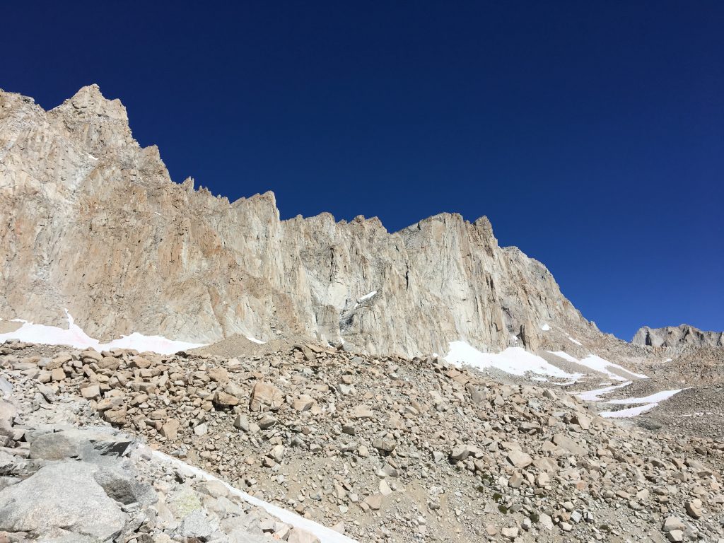
From there, we started one of the most grueling stretches of the hike – the switchbacks. Every source you can find will put a number on how many there are, and I saw everything from 79 to 111. It doesn’t really matter the number (though, for the record, I counted 103 on the way down), just know that this part sucks as you zig-zag your way up the face of a hill, gaining some 1,500 feet to get to Trail Crest.
We stopped a lot during this stretch, little 30-second breaks to catch our breath and 5-10 minute breaks for a quick snack or water. I was getting winded at times. Shannon, who was hurting a lot before Trail Camp, had rebounded and was handling the trail well. Krista was looking a little worse for wear as we moved up.
Somewhere around 13,400 feet or so, with about 80 percent of the switchbacks behind us, Krista called it. She was light-headed and described feeling “cloudy.” Altitude sickness was clearly getting to her, despite doses of Diamox. We took another break as we all rested a bit. Since we were past any water source, we gave her the water filter we had. She headed back to Trail Camp to rest while Shannon and I continued on. Krista absolutely made the right decision.
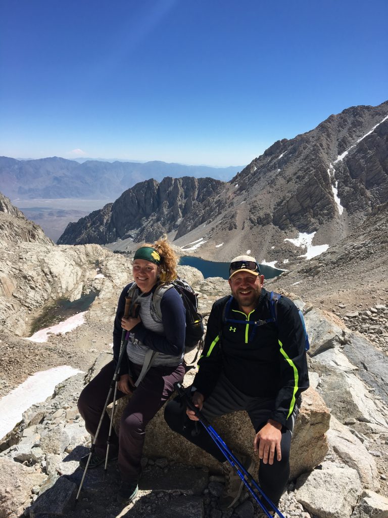
Much like Wheeler Peak, there is a singular moment on this hike that I’ll always remember. When you hit Trail Crest (Elevation: 13,600), your world opens up to the John Muir Wilderness Area and Sequoia National Park. It is such a stunning vista, and after reaching the crest after all those switchbacks, it is an exhilarating reward.
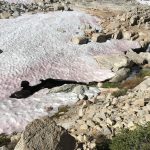
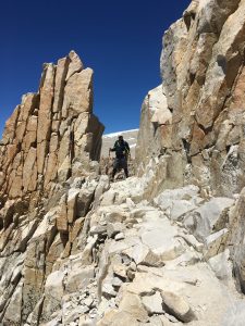
From Trail Crest, there is a couple hundred feet of descent down to the junction with the John Muir Trail. It was a little party zone there, with a large group of families having come up the JMT and their Whitney summit concluding seven days in the backcountry. There was another guy who was finishing the entire JMT and had a broken hand suffered a few days before. Everyone coming down from the summit mentioned an alternate trail route we needed to take for the final quarter- to half-mile as a large snowfield still remained, forcing a more vertical and scrambling ascent to the top.
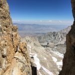
From the crest to the summit is just over two miles. This stretch, in both directions, is the hardest part of the hike, in my opinion. You must descend to the junction and then climb nearly 1,500 feet back up to reach the summit. The trail is rocky and there are some sections where it is a sheer drop-off on one of both sides, and the trail is only a few feet wide.
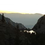
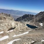
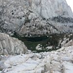
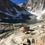
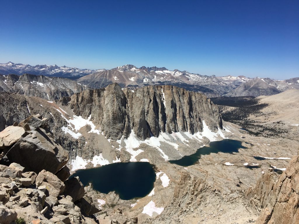
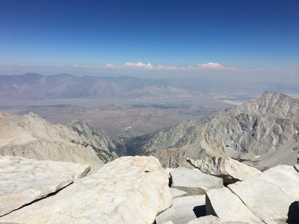
It is a gorgeous section of the hike, to be sure, looking west into the wilderness area with Hitchcock Lake and Guitar Lake. The section of “windows” – gaps in the peaks leading up to the summit – allow for cool views to the east, all the way down to Lone Pine and the valley floor.
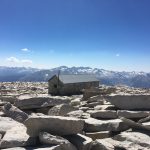
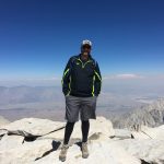
We took our time on this stretch and slowly made our way to the final stretch. The auxiliary trail we had to use wasn’t fun, but was well-marked with cairns and soon the summit hut was in sight. It was mid-afternoon and a father and son were leaving the summit as we arrived, giving us the top to ourselves. The views were grand.
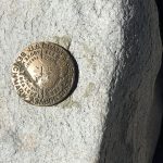
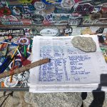
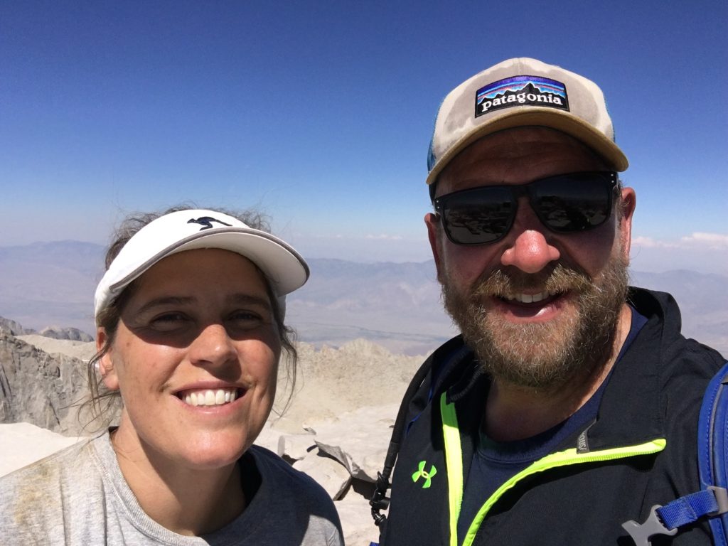
I took some pictures and we spent a few minutes marveling at where we were and how far we had some. With Krista waiting at Trail Camp, we didn’t spend much time at the summit, however. We signed the register to record the moment and headed back down.
It’s a helluva thing to hike up that kind of distance and elevation and reach a summit like that, and have those amazing feelings of accomplish washed out by the fact that you still have ELEVEN MORE MILES to go to be done.
On the return, there are a few small sections of uphill on this two-mile stretch that are not fun. And then you get to the trail junction, you have a few hundred feet up to Trail Crest. This part made me want to vomit, and I’m sure that had a lot to do with descending down to 13,300 or so and then having to climb back up. My body was in descending mode and the sudden climb messed me up. I knew I needed to eat something but I felt anything but hungry. It was a rough 15-30 minutes. Once we reached Trail Crest and started down on the switchbacks, I started to feel better.
We finally got to Trail Camp and Krista looked rested and happy, and a lot better overall than when she had turned back. From there, we started down the final six miles. We wanted to get to Mirror Lake (about two miles worth of trail) before darkness hit because of how rocky and wet that section of the trail was. We managed to accomplish that but overall, those last six miles were rough.
All things being equal, we should have been down around 9 p.m. or so. But all things weren’t equal. We had all of the water crossings to deal with. I rolled my ankle, not once but twice, on the way down. Shannon’s knee was buckling. We were all tired and it was starting to get dark. And to top it off, there was a wildfire south of us – we could see the plumes from the summit – and the winds had shift, blowing the smoke north to our area. As it got dark, I could see the ash in the headlamp, and the moon rose through the smoke with a dark orange color.
It was after 11 p.m. by the time we reached the car. Statistics from the day include:
Mileage: 23.5
Elevation Gain/Lost: 6,600 feet
Steps: 52,111
We were on the trail for nearly 20 hours. According to Strava, we were “moving” for just over 12 hours of that time. Yes, it was a long day. But we were fortunate to not have storms or the threat of lightning in the area and that allowed us to take lots of breaks and pace ourselves.
If you’re looking for more info and specifics on the hike, I suggest checking out posts from the Hiking Guy, Modern Hiker and this Horst-and-Graben non-believer. To be sure, if I ever decide to hike Whitney again, I have a couple of decidedly better ways to go about it.
First, I think it would be cool to spend some time on the John Muir Trail and to summit as a day hike after camping the night before near Guitar Lake (elevation: 11,500 feet). That would be 3,000-feet overall climb – and the trail from Guitar Lake up to the trail junction looked nice – to the summit and out through the Whitney Portal, perhaps camping at Trail Camp or beyond. I even noticed a small camp area right off the JMT, a few hundred feet below the junction. Honestly, though, I’m more interesting in just backpacking the JMT in general than I am summiting Whitney again.
The best option, if only wanting to climb Mt. Whitney, is to get the overnight permit. In retrospect, I wish I would’ve used all 15 of my lottery slots for overnight permits. Instead, I mixed in a few day-trip dates and that’s what I got. Camping somewhere on the trail not only breaks up the 11-mile hike, but more importantly helps you acclimate to the altitude. And although we never really saw it in the daylight, the Whitney Portal Campground was pretty cool. We camped next to the creek and the campsites were well spaced. Ideal situation: A two-night overnight permit in which you hike in on day one and camp at Trail Camp before summiting on a day two and then camping at Trail Camp or lower before exiting at the Portal on day three.
If on a day-hike permit, do your homework and plan for a couple days. This means spending a night camping at Whitney Portal first to help acclimate. If you really only have one night to spare, get on the trail from the portal and camp just outside the permit zone. Get some sleep and get on the trail in the early morning hours. You should summit by noon and get back to the portal by the evening. Like most, we didn’t think we could start the trail from the portal until midnight or later on the one-day permit. In reality, you can start around 10 p.m. or so as you don’t enter the permit zone (a couple miles in) until midnight.
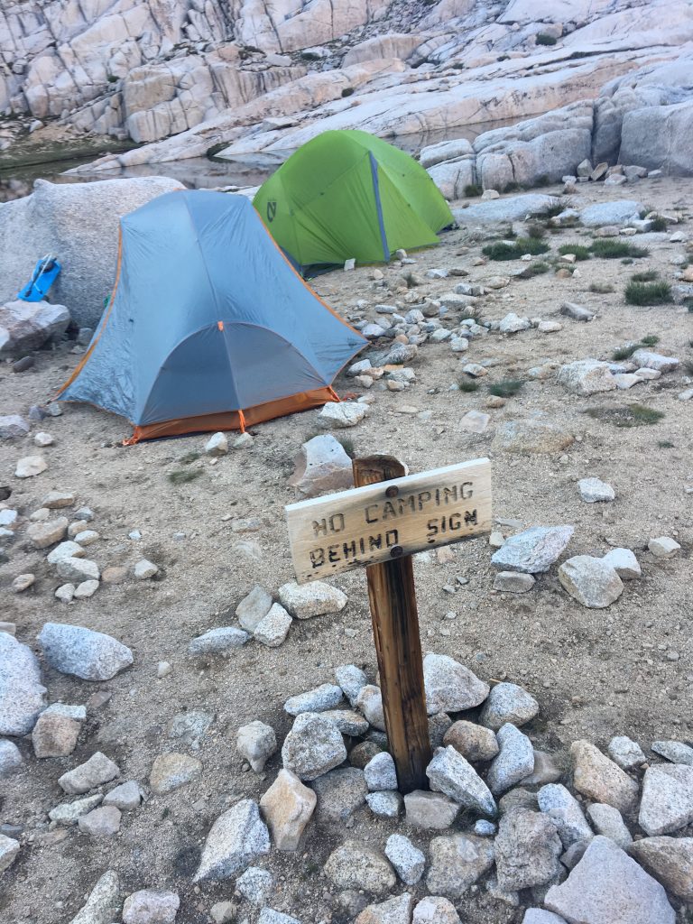
As an aside, this is a reminder that there are idiots everywhere. Because of the demand from hikers hoping to summit Mt. Whitney, and in an attempt to help preserve the environment and eco-system in the national forest, there is a permit system in place. There’s a reason why only 100 day-hike permits and only 65 overnight permits are issued for each day during the hiking season. There’s a reason why you take a wag bag and are required to pack out all trash and waste. There’s a reason why “Leave No Trace” is the prevailing rule. So, when the U.S. Forest Service puts up a sign that says “No Camping Beyond Sign,” rest assured that there’s a reason they do that and yes, the rule applies to you, too. Don’t be these people:
Gear: Overall, I felt pretty comfortable with everything throughout the day. The Osprey daypack was full – I took six liters of water, along with various layers of clothing and enough food for the day, though I never want to see another Clif bar again. Energy blocks served us well, as did plain tortillas (I picked this tip up from Krista on the Lost Coast Trail a few years ago).
To me, trekking poles were a necessity for this hike. They’ll help your knees, especially on the way down. I put some SuperFeet insoles into my Under Armour boots and my feet generally felt good.
Post-hike beer: None. Our post-hike plans of camping, either at the Whitney Portal campground or Lone Pone campground, were derailed with the smoke and ash from the Indian Fire to the south of us. So after 23-something miles and 6,000-plus of elevation ascent and descent and 20 hours on the trail, we got in the car and drove 250 miles home.
To be fair, the intention after getting into the car was to find a motel somewhere in Lone Pine, Independence, Big Pine, Bishop, etc. But the entire 395 corridor seemed to be completely booked for the night. So we just kept driving, with a couple of road-side naps mixed in, and got back to Reno about 6:30 a.m.
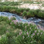
Overall, just know that this hike is absolutely incredible, not just in the achievement of enduring 22-miles and more than 6,000 feet of elevation gain in summiting the tallest point in the lower 48, but also in the sheer beauty of the trail itself. One could argue that the 11 miles of trail is more stunning than the summit vistas, and I’m not sure that I’d argue against that. Here are a few more shots from the hike: